Japan: A Monkey with a Surprising Habit

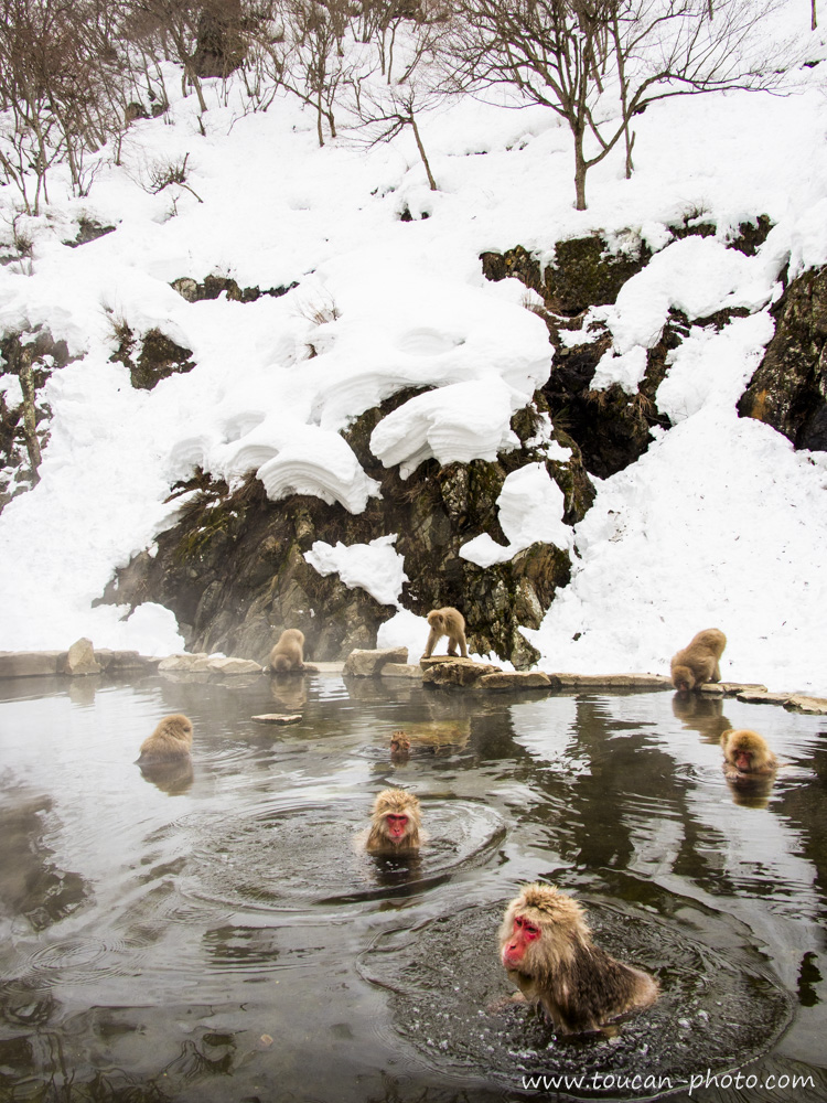
Snow monkeys (in Japanese, nihonzaru 日本猿), also known as Japanese macaques (Macaca fuscata), are the only species of primate living in the wild in Japan. This species is also endemic to the Japanese archipelago. These monkeys are mainly found in mountainous regions, at altitudes ranging from 500 to 2,500 meters. In winter, when temperatures become harsh, these monkeys have developed a surprising habit: soaking in natural hot springs to keep warm!

The Macaca fuscata is endemic to the Japanese archipelago.

Japanese macaque thick fur

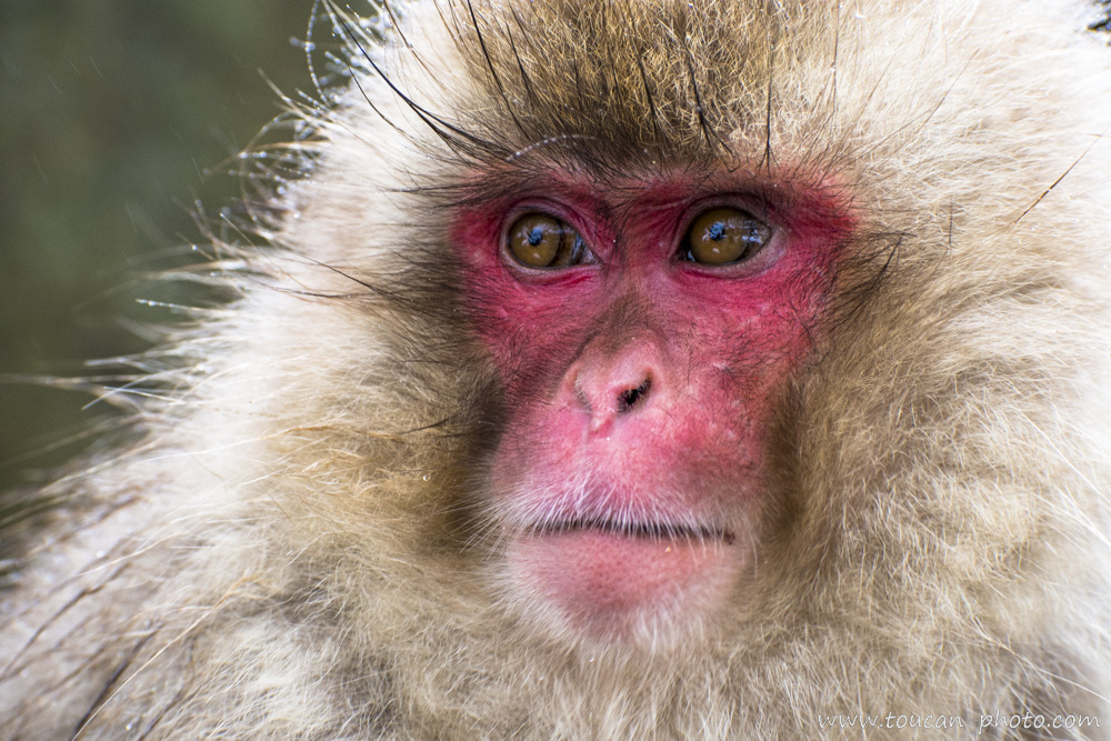
The fur of these monkeys, which ranges from gray to brown, is dense and thick, allowing them to withstand the freezing temperatures and snowy conditions of the mountainous regions where they live.

Like many other monkeys, the Japanese macaque is omnivorous. Its diet includes fruits, roots, seeds, insects, and occasionally even small animals. These monkeys live in complex social groups, ranging from 20 to 100 individuals. These groups are mainly composed of females and their young, while adult males often live on the outskirts of the group or frequently change groups. The nihonzaru, like other primates, have developed complex interactions such as grooming, food sharing, and vocal communication. However, it is another behavior that makes these monkeys truly unique: Japanese macaques have become famous for their habit of frequenting natural hot springs, known as onsen (温泉) in Japanese.

Winter serenity macaques

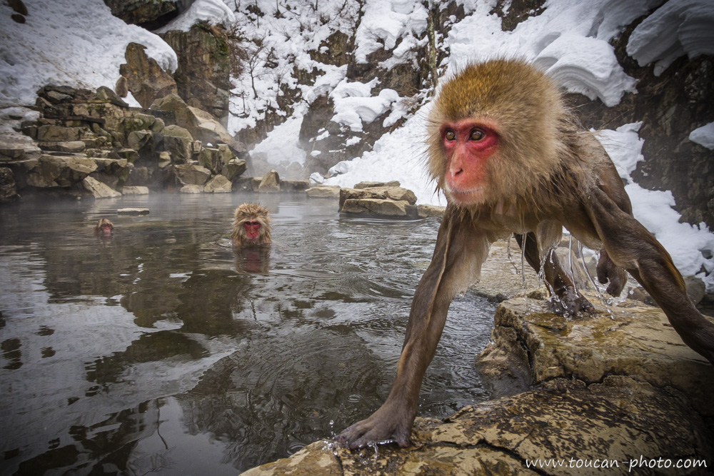
Winter serenity: Japanese macaques enjoying a warm bath amidst the snow.

Macaque savoring onsen warmth

A macaque savoring the warmth of an onsen.

This unusual behavior is believed to have emerged in the 1960s-1970s, when a harsh winter reportedly pushed groups of nihonzaru to seek refuge in natural hot springs. It is even possible that this behavior developed by imitating humans, as bathing in hot springs is a long-standing tradition in the Japanese archipelago. Since then, it has become a habit: every winter, monkeys can be seen relaxing in the warm waters of the onsen. This phenomenon is particularly visible in the Jigokudani (地獄谷) region, located in the mountains of Nagano. The photos presented in this article come from there.

Female nihonzaru and baby

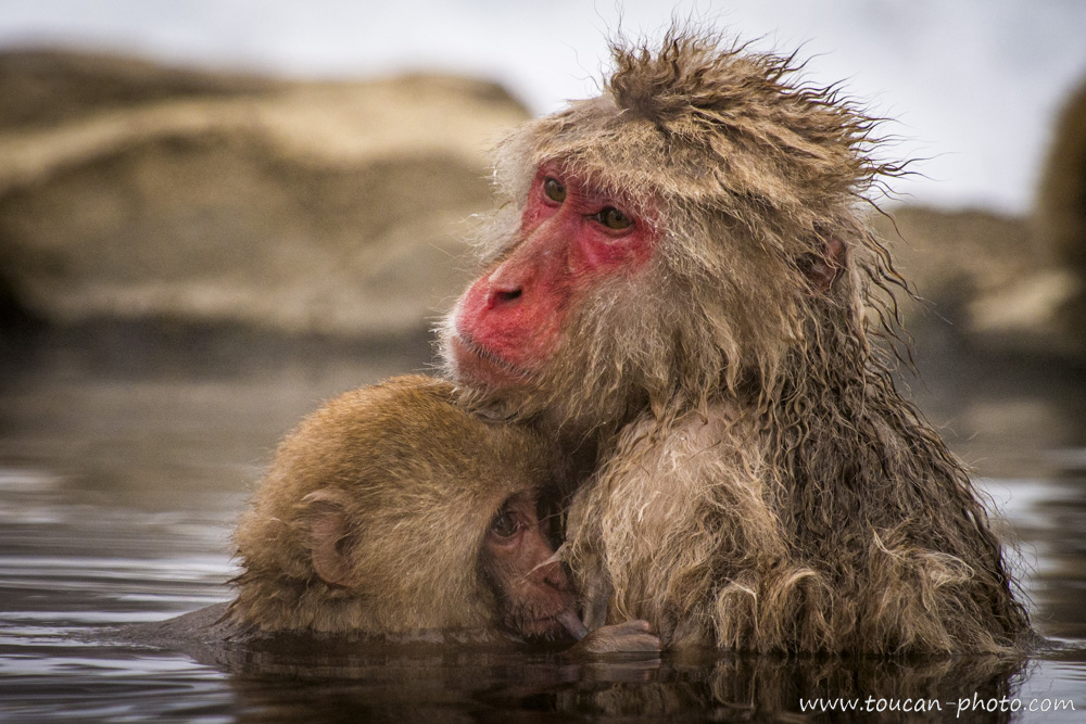
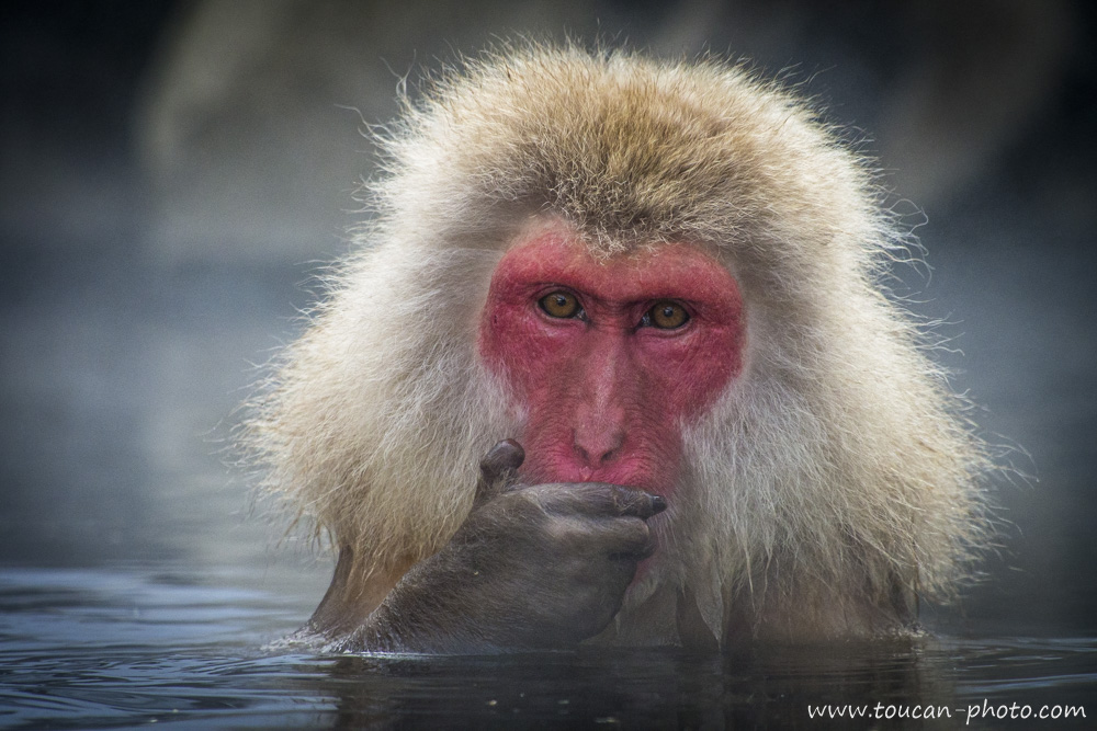
Female nihonzaru nursing her baby in an onsen.

Family grooming

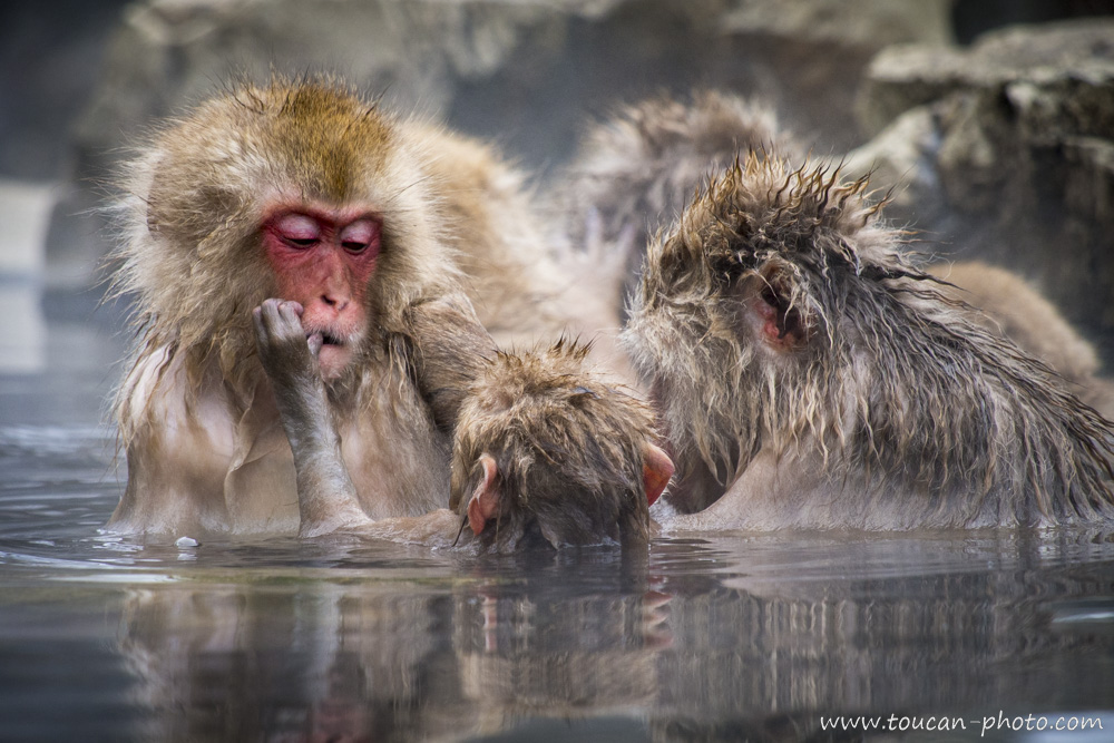
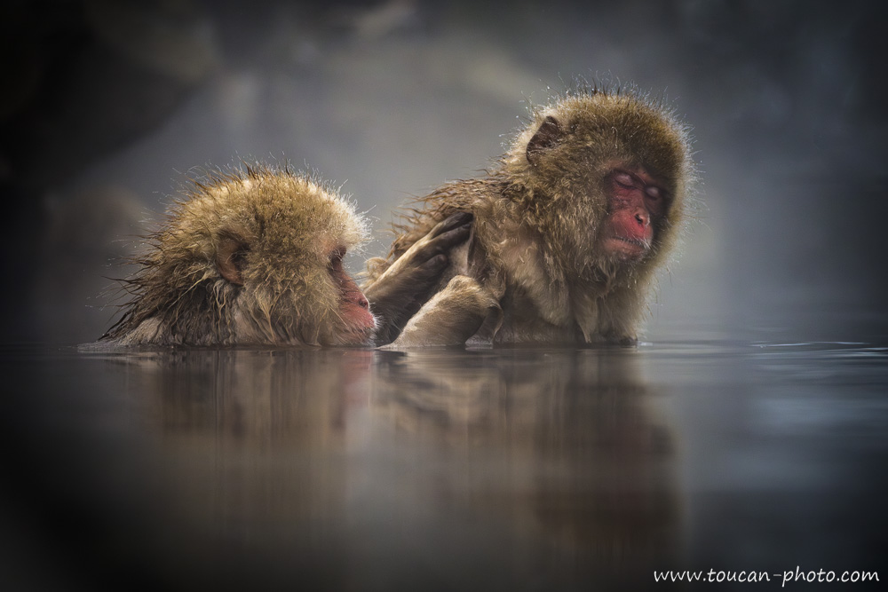
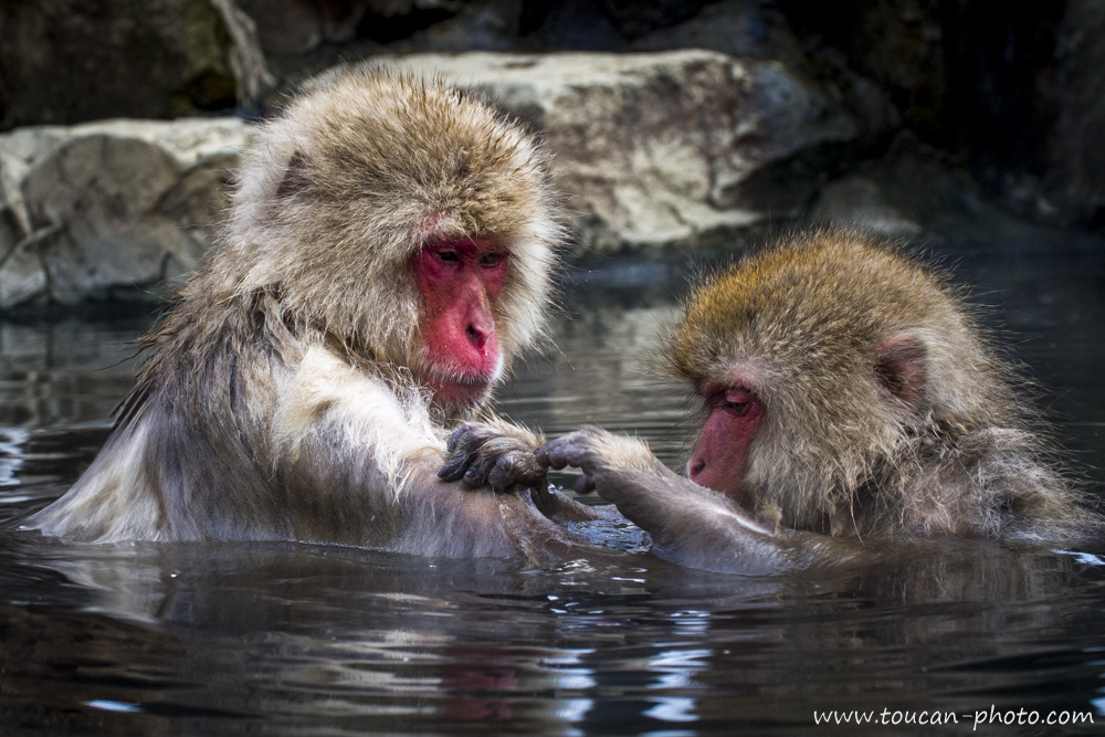
Family grooming time.

Solitary male onsen

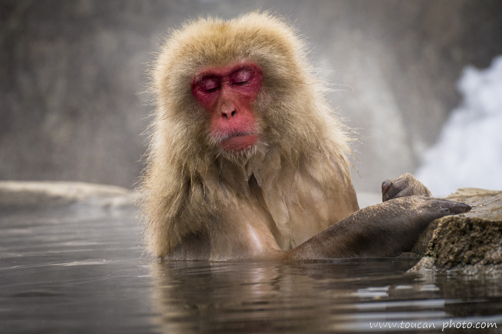
A more solitary male also enjoys the comfort provided by the warm water.

As with many other primate species, social hierarchy plays a central role in the organization of Japanese macaque groups. These groups are led by a dominant female, often the oldest and most experienced, who exerts significant influence over the other members. Adult males also hold an important status, but they often have to prove their strength to lead a group. This hierarchy is also reflected in access to the onsen. Dominant macaques, whether male or female, are the first to access the hot springs and can enjoy them for as long as they wish. Subordinate individuals, however, must wait their turn and only have limited access to the onsen. This difference in privileges can create tension within the group. Competition for these thermal spots can be particularly intense during the coldest months, when the monkeys need warmth to survive.

Hierarchy at the onsen

Time to give up the spot.

Searching for parasites

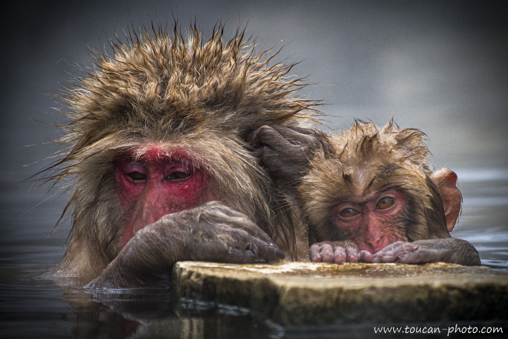
Searching for parasites.

Macaque reflection

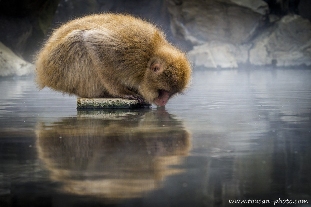
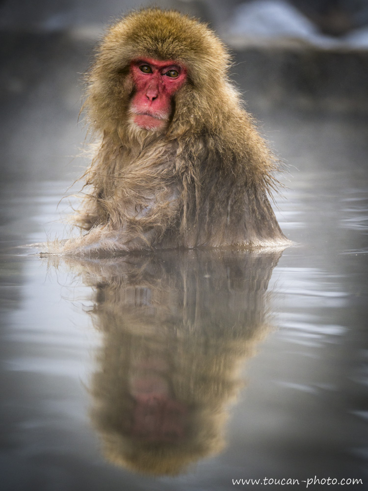
Drinking or admiring its reflection?

While some Japanese macaques protect themselves from the winter cold by immersing in natural hot springs far from cities, other groups of monkeys regularly visit public onsen located in spa towns. For hygiene and safety reasons, these onsen were eventually abandoned by city dwellers and have since been frequented only by monkeys. Tolerance towards monkeys in urban areas is not so surprising. In Japanese culture, the macaque is often associated with spiritual and mythological elements. It is considered a messenger of the gods and is revered in many Shinto traditions. Moreover, the image of a macaque relaxing in hot water echoes the concept of purification, an essential practice in Japanese culture, particularly in traditional thermal baths. Monkeys in onsen embody a form of communion with nature and the divine, which explains why they are warmly welcomed in certain urban hot spring resorts.

Old male macaque

Old male.

Comfortable grooming onsen

Comfortable grooming.

The presence of macaques bathing in onsen during winter has since generated additional tourist interest for certain hot spring towns. The nihonzaru have, in a way, become mascots that people can observe in winter as they relax in the warm waters. However, this growing proximity between macaques and humans has also led to some challenges, particularly due to tourists developing the habit of feeding the bathing monkeys. This disrupted the monkeys’ feeding behavior to the point where they no longer searched for food on their own, becoming dependent on humans. Some even became ill due to an unsuitable diet. Many tourists also sought close contact with the monkeys, wanting, for example, to pet them, which caused additional stress for the animals. Strict regulations have since been put in place to ensure that macaques are no longer fed by visitors and that interactions between monkeys and humans remain respectful. This allows the monkeys to fully enjoy the comfort provided by the hot springs.

At peace in onsen

At peace in an onsen.

Thoughtful gaze macaques

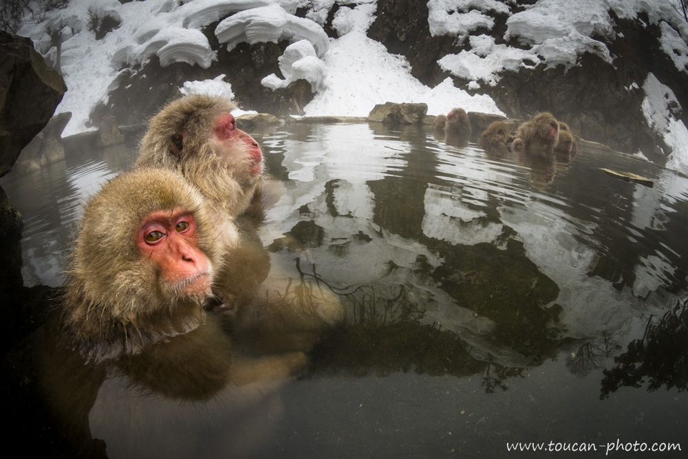
Thoughtful gaze and winter steam: a tranquil immersion for these macaques in the mountains of Nagano.


— Continue the journey —

See more pictures from Japan

See more pictures of mammals

— Complementary Resources —

Macaca fuscata on Wikipedia


Ethiopia: The salt from lake Karum

Lake Karum is a salt lake located in Ethiopia, at the northern end of the Great Rift Valley. This lake, as well as the volcanoes of Dallol and Erta Ale, are among the most improbable landscapes of the Danakil Depression. This place also offers a timeless spectacle. Indeed, perpetuating a centuries-old tradition, Tigrayans travel to Lake Karum from the Ethiopian highlands, followed by long caravans of dromedaries and donkeys in order to recover salt slabs from the dry areas of the lake, a vestige of a time when the sea still flooded the Danakil Depression.

Location of Lake Karum and the Erta Ale and Dallol volcanoes

The Great African Rift Valley map

The Great African Rift Valley

Danakil Depression landscape

A classic landscape of the Danakil Depression.

It is one of the hottest places on the planet; the mercury can climb up to 58°C.

Arid landscape near Lake Karum

Another landscape not far from Lake Karum. Here, rainfall does not exceed 20 or 30 cm per year.

This depression is at an altitude of 120 meters BELOW sea level. A rampart of rock prevents the water of the Red Sea from swallowing up the Danakil. However, it happened several times throughout history that this rampart topology changed due to moving tectonic plates and volcanic activity in the region, allowing the waters from the Red Sea to penetrate and completely flood the Danakil Depression. This phenomenon last occurred about 30,000 years ago. Following this, the Danakil found itself again isolated from the Red Sea. The water present in the Danakil Depression then slowly evaporated, leaving a layer of salt that can reach up to 2,000 meters thick in some places.

Marine coral skeletons in the Danakil

These marine coral skeletons found in the Danakil bear witness to the last flooding of the depression by the Red Sea, which occurred 30,000 years ago.

Lake Karum with a thin layer of water

When it rains on the Danakil, the water follows the slope of the reliefs and flows to Lake Karum. In this photo, the lake is covered with a thin layer of water.

Salt evaporation shapes

The evaporation of water creates strange shapes made of salt.


Lake Karum salt plain

Lake Karum then becomes a salt plain, with an area of about 50 km² (18km long by 5km wide). Under the rays of the sun, the light reflected by this expansion becomes blinding.

Tigrayans and caravans

For millennia, Tigrayans have traveled to Lake Karum from the Ethiopian highlands, located more than 100km away. They are followed by long caravans of camels and donkeys. It takes between 2 and 3 days of walking for the Tigrayans to reach Lake Karum.

Camel caravan arrival

A camel caravan arriving at Lake Karum.

Salt extraction morning

The extraction of salt is only done in the morning.

As temperatures become oppressive in the afternoon, it becomes impossible to work. To extract the salt, slabs are cut with axes. These slabs are then lifted using wooden levers.

Axe for salt cutting

An axe used for cutting salt slabs.


Amolé salt tiles

The extracted slabs are then re-cut and straightened into smaller tiles called amoles.

Each amole weighs between 5 and 8 kg.

Cutting an amole

Cutting an amole tile.

Using adzes

The cutting of the amoles is done using adzes.


Salt for livestock feed

The salt harvested from Lake Karum will be used mainly for livestock feed.

Loading cargo onto dromedaries

The camel herders load the precious cargo onto the camels. During the return trip to the Tigray plateau, each dromedary will be loaded with a hundred kilos of salt.

Caravan heading to Mekele

A caravan leaves Lake Karum and takes the direction of Mekele, located in the Tigray region.

Caravan under moonlight

Taking advantage of the mild evening and the moonlight, a last caravan leaves Lake Karum with its load of salt.


Algeria: The Tadrart Rouge, a window to the Sahara and its history

Larger than Australia with its 8 million square kilometres, the Sahara has not always been the biggest hot desert on the planet. About 15,000 years ago, it was a green period brought about by a warming phase that had intensified evaporation from the top of the ocean and pushed the monsoons into the heart of the North African continent. The arid landscapes that we know today were then covered by large lakes and rich vegetation. Elephants were living there, as well as hippos, crocodiles and humans too. Those ones, as to immortalize this full of life period, have drawn paintings and engravings cut out of rock. These testimonies of the past are omnipresent in Tadrart Rouge. Indeed, this Sahara’s fragment is located in south-eastern Algeria and offers the vision of over 15,000 engravings to the brave who dare adventuring themselves into there. Over the sand dunes and rocky peaks, the traveller will discover, at the same time as breathtaking landscapes, a touching testimony of the past.

The Tadrart Rouge, located on the Algerian south-east part

Sahara landscape scale

Sahara composition is about 20% of sandy surfaces and about 80% of rocky surfaces, mostly sedimentary rocks. The hiker on the right allows us to imagine the landscape scale.

Tadrart Rouge overview

Tadrart Rouge overview

Ancient engraving

Here you can see one of the 15,000 engravings that can be discovered into the Tadrart Rouge. The oldest ones are estimated to be about 12,000 years old.

Giraffe engraving

Another engraving, this time staging giraffes. The character on the left seems to be a hunter.

Moulnaga peak night photography

Night long exposure photography of “Moulnaga” peak, located in the heart of Tadrart Rouge. The 3 hours long exposure allowed the stars to trace these beautiful light full arabesques.

Sand arabesques

During the day, we can see another kind of arabesques: the ones drawn by the wind in the sand.

Tifinagh alphabet on rock

Tifinagh (“ⵜⴼⵏⵗ” or “ⵜⵉⴼⵉⵏⴰⵗ”) is a Berber alphabet existing for about 6,000 years. It can be found in many writings, like here on this rock photographed at night with the Milky Way as background.

Rock paintings

Additionally to the engravings, we can see many paintings directly on rock. Human characters are staging in what seems to be daily life representation: dances, songs, hunts, etc.

Lonely hiker

A lonely hiker in the desert.

Milky Way and Acacia

Milky Way photography with an Acacia forefront. Although its 15-meter deep roots make it very drought resistant, this tree remains quite rare in the Tadrart Rouge.

Tadrart Rouge vastness

Tadrart Rouge vastness. Behind the dark rock barrier, the Tadrart Rouge extends to Libya, which can be seen in the background.

Footprint engravings

Engravings of animal footprints.

Wind patterns in sand

The wind models dunes and draws in the sand thanks to dry blades of grass.

Desert lines

While some can spend many hours admiring the pared down lines of the desert…

4x4 in the desert

… Others choose to ride at full speed through Tadrart Rouge windings.

Marine fossils

Those marine fossils remind us that, once, water was here in abundance. About 100 million years ago, the sea was covering part of the Sahara.

Dried up Guelta

Burning sun over a dried up Guelta. The bowl form of the ground retains water during rare rainfalls, which then evaporates, letting this thin cracked clay crust.

Pared down rock painting

Old rock paintings realized in a very pared down style.

Complex rock painting

More complex rock painting. Depending on the eras, different techniques and styles succeeded one another.

Sand and Rock

Sand and Rock

Sunset in Tadrart Rouge

Tadrart Rouge’s sunset


Russia: The Baïkal lake during winter, frozen pearl of Siberia

Under the Siberian’s winter freezing temperatures, Baïkal lake’s surface is changing into ice several months a year, usually from beginning of January to May. The 1 to 2 meters thick ice, allows people and even cars circulation on it. The following photos have been taken during a frozen lake’s foot crossing. Several aspects of the ice, sun ray’s reverberation on it, the lights playing through the “Toros” are as many photogenic subjects that would make this crossing unforgettable.

The Baïkal lake (in Russian : “Озеро Байкал, Ozero Baïkal”) is located in Russia, in south part of Siberia.

You can’t possibly not use superlatives to describe Baïkal Lake. This lake, which is twenty-five million years old, is the oldest existing lake. Baikal, which is 636 km long and up to 79 km wide, is also the largest lake in the world. And with a depth of up to 1642 meters, it is the deepest on the planet. Baikal’s huge dimensions make it the largest reserve of liquid fresh water in the world. This means 23,600 km3 of water, or 23,600,000,000,000 cubic meters. This volume of water would be enough to cover with liquid 1.6 cm all the Earth’s land surface. Imagine that the water of Baïkal Lake is completely frozen and cut into ice blocks. If these blocks were used for the construction of a wall measuring 1,000 height meters and 100 thick meters, there would be enough material for the building to be 240,000 kilometers long, long enough to go around the world six times.

Olkhone Island Baikal

View of the frozen lake that has just covered with a snowpack. This photograph was taken from Olkhone Island, located about 15 km from the lake’s West shore, which can be seen in the background. The lake has 27 islands, and Olkhone, which is 70km long, is the largest one of them.

Walker on frozen lake

At sunrise, lonely walker goes to discover the frozen lake.

Panoramic view Baikal

Paranomic view from the lake to the coast. Breaking zones are numerous on the lake. They are the result of the frozen cover almost “tectonic” activity.

Cracked ice layer

A first ice layer, still thin at the beginning of winter, cracked before the cold froze again the surface of the lake.

Ice thorne

Ice thorne.

Ice thickness Baikal

Under my feet, about 120cm of ice. After digging the ice, it would take about 1540 meters diving to reach the bottom of the lake.

Toros entanglements

The frozen lake’s surface endures various pressures because of depth’s currents, temperature changes, pressure that it is exerted and that it receives from liquid water, etc. The frozen surface ends up cracking and the resulting plates overlap each other creating the so-called “Toros” entanglements.

Sun rays on ice

Driven by the rays of the setting sun, the surface of the frozen lake sparkles with a thousand splinters.

Trapped ice fragments

Ice fragments trapped within the frozen surface thickness.

Baikal frozen surface

Night view star movements

Night view on the frozen lake’s surface. A long exposure photograph captures the star’s movements.

Snow and wind

Snow swepts by the wind.

Moon reflection Baikal

The moon also reflects on Baïkal Lake. This photo was taken at night during the moon rising.

Fire block ice

This ice block, crossed by the sun rays, turns itself into a fire block.

Bear Mountain Baikal

This ice just cracked there, creating a flaw as well as new “Toros”. In the background you can see the “Bear Mountain”, located on the East bank of the lake.

Long exposure stars

Another long exposure of the star-full sky, with a “Toros” covered with snow in the firstground.

Buryat shamanic ribbons

The first living souls to settle in Baïkal Lake area were Buryats, from Mongolia. They had chamanic beliefs. Buryats first considered Baïkal Lake as a sacred sea. The chamanic ribbons tied the this tree, which overlook the lake, are so many prayers and attentions addressed by the Buryats to their ancestors.

Eroded ice fragment

Fragment of eroded ice.

Ice on Baikal

Moon on dark ice

The moon reflecting on the dark ice.

Sunset Baikal

Sunsets are proof that endings can sometimes be beautiful too. – Beau Taplin

One of the Baïkal Lake’s tributaries is the Selenge River. This river is partially fed by the Eg River, which itself originates from Khövsgöl Lake, located in Mongolia. An article about it is available here.


— Continue the journey —

All images from Russia

— Complementary Resources —

Lake Baikal on Wikipedia


Palau: Snorkeling in the Jellyfish Lake

The Palau archipelago, located in the Western Pacific east of the Philippines, consists of more than 250 islands. Most are uninhabited, covered in primary tropical rainforest and mangroves. While this description already promises adventure, the existence of a lake populated by millions of jellyfish on one of these islands makes the region truly extraordinary.

Location of the Jellyfish Lake

Boat to Eil Malk

Boat approaching Eil Malk Island

The island of Eil Malk (or Mecherchar) measures 6 km by 4.5 km with an area of about 19 km². Like the majority of the islands in the archipelago, it is not inhabited by humans due to its small size.

Lake in tropical forest

This island has several lakes. One of them, nestled in the green setting of the tropical forest and bordered by mangroves, looks like any other lake in the region when observed from the shore…

Immersion in Jellyfish Lake

…but when you dive, you discover the fantastic treasure it holds: welcome to Jellyfish Lake!

12,000 years ago, falling sea levels trapped a large volume of water and its inhabitants in a natural basin in the heart of the island. This is how “Ongeim’l Tketau” lake was formed. In the absence of predators, the jellyfish flourished until they completely took over the waters, which today are fed mainly by rain.

Golden jellyfish Mastigias sp.

Golden jellyfish (Mastigias sp.)

The lake mainly contains two species: the golden jellyfish (Mastigias sp.) and the moon jellyfish (Aurelia sp.). The lake covers 57 hectares (460 m long by 160 m wide). With a population once estimated at about 8 million individuals, an encounter is inevitable with every movement of a fin.

Swimmer among jellyfish

A swimmer among the jellyfish

Although they still have stinging cells, these jellyfish are harmless to humans: their “stings” are too small to be felt through human skin.

Throughout the day, the jellyfish follow the sun. They host a symbiotic algae, zooxanthellae, which produces nutrients through photosynthesis. In exchange for protection, the jellyfish benefits from this food generated by light. They also descend deeper to seek nitrogen, but never exceed 15 meters: beyond that, the water becomes anoxic (deprived of oxygen) and toxic to most organisms.

Under a jellyfish sky

Under a jellyfish sky

Since 2016, the population has dropped from 8 million to about 600,000 specimens. Scientists suspect the El Niño phenomenon: drought reduces the influx of fresh water, increasing the salinity of the lake beyond the threshold for jellyfish development.

Jellyfish hope

Jellyfish in the Jellyfish Lake of Palau

A similar situation occurred in the late 90s after another El Niño episode. The population rebuilt itself then; we hope history will repeat itself.


— Continue the journey —

More aquatic life images

— Complementary Resources —

Jellyfish Lake on Wikipedia


Ethiopia: The Erta Ale volcano and its lava lake

Erta Ale is an Ethiopian volcano located in the Afar region, in the northeast of the country, within the East African Rift Valley. Standing 613 meters high with a base diameter of 30 kilometers, its broad, low-profile shape classifies it as a “shield volcano.”

At the summit of this highly active volcano lies a caldera containing two pit craters. The South Pit, 200 meters in diameter, is currently the most impressive as it houses a permanent lava lake where molten rock reaches temperatures of 1,200 degrees Celsius. The lake’s level fluctuates constantly; in January 2017, it rose high enough to overflow. By April 2017, the level had dropped, offering observers a spectacular and cyclical phenomenon of emptying and refilling, which can be seen in the videos at the end of this article.

Location of the Erta Ale volcano

Erta Ale volcano overview

In the Afar language, “Erta Ale” means “Smoking Mountain”

From the base of the volcano, columns of smoke escaping from the craters are clearly visible. Because of this, the Afar people have long considered this mountain “cursed.” This photograph also highlights the very flattened profile characteristic of shield volcanoes.

View of North and South pits

View from the North Pit crater. In the background to the right, the South Pit of Erta Ale is visible.

Lava field landscape

The surroundings of the craters form a dramatic landscape

The “cliff” visible in the image above is actually a section of the caldera. A caldera (from the Latin for “cauldron”) forms when the summit of a volcano collapses after a massive ejection of lava leaves the magma chamber hollow. The Erta Ale caldera is oval-shaped, measuring 1.6 km by 0.7 km.

Lava lake at night

The lava lake of the South Pit, photographed at night. In April 2017, the level was approximately 80 meters below the rim.

Lava burst Erta Ale

Small lava burst

The lava is kept molten by extremely hot gases rising from deep underground. These gases create lava fountains that are particularly impressive when the lake level is low.

Empty South Pit

Intermittently, the lava lake disappeared into the depths of the volcano before returning to its original level. In this photo, the lake has completely vanished.

Crater scale with observer

The South Pit at the end of the day. The observer at the top right provides a sense of the crater’s immense scale.

Observers on crater rim

More observers on the edge of the South Pit

Cooling lava surface

Lava at the surface cools and solidifies into dark, shifting plates

Detail of lake surface

Detail of the lava lake surface

Lava patterns

Another view of the lake’s surface

Lava explosion night

Lava explosion

Sunset at Erta Ale

Sunset over the desolate landscape of Erta Ale

Toucan photographer at crater edge

The Toucan on the edge of the South Pit

Smoke under stars

Observing the smoke plumes under the stars

Volcanic smoke

Taming the smoke plumes rising from the crater

Empty South Pit floor

The South Pit once emptied. This drainage process occurs in just a few minutes.

Glowing crater floor

Close-up of the bottom of the crater after the lava lake has drained into the bowels of the earth

At this moment, the heat radiating from the edge of the pit becomes truly unbearable.

Time-lapse (6x) showing the emptying and refilling of the South Pit. Duration: 2 min.

The same sequence shown at real speed. Duration: 12 min.


Brazil: The Boto, pink dolphin of Amazonia

23 to 7 million years ago, during the Miocene era, Amazonia was partially covered by seawater. Cetaceans were living in this area. When seawater has been definitely out of Amazonia ground, a species would have adapted to continue living in rivers, drawing the Amazonian landscape. This species became the Boto, known also as the biggest pink dolphin of Amazonia.

Genus Inia range of distribution

Genus Inia range of distribution. Represented in green, the distribution of Inia g. geoffrensis, also known as the « Boto ».

In the Amazonian pond, the water of rivers can have different colors. Some rivers appear to be ochre (sometimes whitish) and derive their color from the big quantity of clay. This is the case, for example, of the Amazon river. We can barely see under the water in this kind of river. Others, called ‘black water’ derive their color from the huge concentration of iron and decomposing organic materials. These rivers are very acid, such as the Rio Negro. Despite this ‘tea’ color, the water is not unclear and even when it is dark we can see up to 2 meters deep. The photographs presented in this article have been made in the dark waters of Rio Negro.

Boto at the surface

At the surface, we see the pink color which is a characteristic of the Boto.

Orange color in Rio Negro

In the « tea » color waters of Rio Negro, the dolphin seems to have an orange color.

The Boto, at adult age, measures around 2.80 meters long and weights up to 150kg for the male. The female are generally smaller, measure about 2 meters and weight around a hundred kilos. This dolphin lives exclusively in fresh waters of the Amazon pond. We can see them in Peru, in Ecuador and Bolivia but more specifically in Brazil. These pink dolphins are part of the 5 smartest cetacean species in the world. They are very sociable and can be approached from a boat or even under water. The Boto will have an aggressive behavior only if he feels threatened.

Darkness in deep water

The darkness occurs as depth increases. After few meters deep, it is really dark.

Dolphin muzzle surface

Dolphin sharping the surface with its muzzle.

Anatomical Flexibility: Unlike other dolphins, the Boto has a very short dorsal fin in order not to be shackled when it moves under the immersed roots. Moreover, its cerebral vertebrae are not brought together, giving it incredible flexibility. Thus, the Boto is capable of spinning the head at 90° (an incredible feat for a cetacean), facilitating its movements between trees in flooded area.

Boto short fin

The Boto uses echolocation (sophisticated sonar on the forehead) and has whiskers on the muzzle capable of transmitting surrounding vibrations (similar to a cat’s whiskers). These advantages enable the Boto to detect and hunt fishes with accuracy even though the visibility is often weak.

Boto levitation

The Origin of the Color: Young Botos are grey and male adults are much more pink than females. One theory suggests the color comes from their playful and warrior character. Botos love arguing and nipping each other; the resulting scar tissue is pink, giving them their characteristic color over the years.

Boto healed skin

A Boto and its healed skin.

Playing with teeth

Reproduction occurs between September and December at the lowest water level. After 10 to 11 months of gestation, the female gives birth to one baby (when water is highest). The calf is 80 cm long and grey. The mother suckles the baby for about a year, and independence is reached after 2 to 3 years. Sexual maturity is between 6 and 10 years old.

Boto in the wild

The Boto eats essentially fishes (more than 50 species). With a solid jawbone, it can also break the shells of crabs and river turtles. An adult Boto eats around 2.5% of its body mass every day (averaging 3kg of fish).

Hunting dolphin

Legends and Folklore: Native legends say the Boto can take human form to infiltrate villages. He wears a hat to hide his respiratory vent and seduces young girls. This led to the expression « It is again the Boto » to explain unplanned pregnancies. Other stories mention fishermen fixing garlic to their boats for protection, or a mermaid queen dragging men to the bottom.

The Rio Negro mermaid

The Rio Negro mermaid, sometimes considered as the Botos’ queen.

Mystical Boto

Mystical Boto.

The Boto population is estimated at 100,000, but survival is compromised by poaching (used as bait for Piracatinga), mining pollution, and dams. About 7,000 Botos are killed each year. We hope it will not disappear like its Chinese cousin the Baiji, not seen since 2007.

Boto family


— Continue the journey —

More aquatic life images

All images from Brazil

— Complementary Resources —

The Boto on Wikipedia


Mongolia: The Khövsgöl lake

Called the « Blue Pearl » because of its water purity, the Khövsgöl lake (in mongolian : ᠺᠥᠪᠰᠦᠭᠦᠯ) is a sacred place for the local people, which they call « Mother ». The below pictures were taken at summer time, during a several weeks horse ride on the lakeside. More than a view on the lake, these photos show also the local inhabitants met during this trip.

Location of the Khövsgöl lake

The Khövsgöl lake is located in the north of the country, near the Russian border, in the eponymous province : The « aïmag de Khövsgöl » (in cyrillic mongolian : Хөвсгөл аймаг). The population density in this province is only 1,2 inhab./km2 (the average in Mongolia is about 1,7 inhab./km2)

View on the Khövsgöl lake

The Khövsgöl lake has a lenght of 136km, a width of 36km and its deepest point is at 262meters. Which makes it the second-most widest and the deepest lake in Mongolia. This lake holds almost 70% of Mongolia’s fresh water and its volum of 480 km² makes it the 19th biggest lake in the world.

Pursuit in the steppe

A Darkhad rider (a mongolian ethnic group living in the area) bringing together a herd of horses. As him, today, more and more horse riders prefer to use motorbikes for some tasks as to follow the herd.

Mongolia Khövsgöl

Sunset Delgerkhaan

A sunset view on Delgerkhaan, the mountain range located on the west side of the Khövsgöl nuur

Sheperdess milking

At evening, a sheperdess does the second milking of the day. Each family breed cows, sheeps, goats and sometimes yaks. The agriculture is not widespread in Mongolia, only 0,6% of lands are used for agriculture (To compare, it is more than 33% in France (2015).

Horse riders lake side

Horse riders on lake side

Traditional Ger

The “Ger”, means “Familly” in Mongolian, it is the traditional mongolian housing. The foreigners wrongly call it a “Yourte”, which is in fact the Russian translation. A Ger provide a ground surface of 15 to 30 meters square to its inhabitants. Two Mongolians can set up this house in around 45 minutes and disassemble it in 30 minutes. The structure is made of wood and is covered by felt. Its isolating properties, allow the house to stay fresh in summer and keep a familly warm during winter with the help of a wood, despite the extremely low temperatures.

Khövsgöl bank sunset

The Khövsgöl bank at sunset. The Khövsgöl lake is a cousin of the Baïkal lake, which is world-famous and located in Siberia, 195 km to the north. Both lakes were made by the same tectonic shift. The Khövsgöl lake would be from 2 to 5 millions years old.

Bicycling in the steppe

Bicycling in the steppe

Sacred Khövsgöl

This region is sometimes victime of drought, so the lake Hovsol that provide fresh water to the three main ethnic groups of the region (thee Darkhads, the Bouriates and the Tsaatanes) is considered are sacred by local inhabitants.

Taïga and streams

This small stream emerging from the Taïga will merge with one of the 96 riviers which will flow into the Khövsgöl lake. Thus, even if a hundred of rivers flow into the Khövsgöl lake only one goes out, it is the Eg river. It will travel 1000km before it flows into the Baikal lake, in Russia. The Taïga, that you can see in the background, is the biggest forest in the world (10% of the emerged lands of the world). This forest is mostly located out of Mongolia, but its edge is at the extrem north of the country near the Khövsgöl lake.

Kushi and her grandma

Kushi and her grandma

Deadwood Khövsgöl

Deadwood on Khövsgöl lake side

Darkhad valley

The Darkhad valley (Mongolian: Дархадын хотгор). This mountain range along the west coast of Khövsgöl lake is itself surrounded by the Darkhad valley. It is covered by steppes, which will feed the herds.

Flower lake side

Flower on the lake side. On the second plan, we can see the east lake side. Contrary to the west side that is mountainous, the eastside has a flat landform.

Horses and rider

This horse is watching the horse rider, which is watching another horse, the Toucan’s mount.

Chuluun and Kushi

Chuluun (means “Stone”, “Rock”) and his little sister Kushi (means “happy life”). In Mongolia, the male surnames are meant to be the expected characteristics by the parents for their child, for example : Bat (Strong), Bold (Steel), Chuluun (Stone) are frequent names for men. About women, they often have flower names or a quality as a name, as Oyuun (Wisdom), Udval (Chrysanthemum, Narantsetseg (Sunflower), …

Yak in Darkhad valley

Due to the climate disruption of these last years, it is more and more difficult for the breeders to ensure the survival of their herds. The “dzud“ are becoming more and more frequent. A “dzud“ is a climate phenomenon defined by an extremely rough winter. The temperatures can drop to -40°C or -50°C for months. Furthermore, if the raining falls are too heavy, the snowpack will be too thick to let the herds be able to reach the food. If this rough winter is followed by a scorching summer, the animals that cannot recover their stock of fat, die by thousands. During winter 2009/2010, a severe “Dzuz” stricked the mongolian steppes, more than 8,5 millions head of cattles died, which is around 20% of mongolian herds. The winter 2015/2016 was again very rough for animals. 858,100 cattles had already perished, on the 7th April 2016.


Philippines: The Marine Park of Tubbataha

Located in the Philippines’ Sulu Sea, the Tubbataha Reef became a protected marine park on August 11th, 1988. This 968 km² sanctuary was added to the UNESCO World Heritage list in December 1993. In the Sama language, Tubbataha means “a long reef exposed at low tide,” referring to its two large atolls, each featuring a tiny islet at its center.

Its extreme isolation—situated 181 km from Puerto Princesa—has been its greatest protection. These two minute islands, rising no more than two meters above sea level, host an incredible abundance of life. Underwater, explorers can encounter over a thousand species of fish, from the tiny anthias to the majestic whale shark, all thriving within pristine coral gardens.

Location of the Tubbataha Reef Marine Park

Juvenile Redfin hogfish surrounded by Anthias

Juvenile Redfin hogfish (Bodianus dictynna) surrounded by Anthias

School of Bigeye trevally and Subergorgia coral

School of Bigeye trevally (Caranx sexfasciatus) and Subergorgia sp coral

Whale Shark Rhincodon typus

Whale Shark (Rhincodon typus)

Reaching up to 20 meters in length and weighing 34 tons, the whale shark is the largest fish on Earth. Harmless to humans, it feeds exclusively on plankton and can live up to 150 years.

Yellow feather star on coral

Yellow feather star

A member of the crinoid class, the feather star uses its cirrhes (articulated claw-like fingers) to crawl and cling to objects. Most species are sedentary and only move if forced.

Barrel sponge Xestospongia testudinaria

Barrel sponge (Xestospongia testudinaria)

This animal can filter up to 200 liters of water daily and live for millennia. Some specimens in the Southern Ocean are estimated to be 23,000 years old.

Corals assembly with anthias

This assembly of various coral species provides shelter for numerous anthias and glass fish

Longfin bannerfish Heniochus acuminatus

Longfin bannerfish (Heniochus acuminatus)

Adults live in pairs and feed on zooplankton. Solitary juveniles often act as cleaners for other fish.

Underwater coral garden

Coral garden

Green turtle Chelonia mydas

Green turtle (Chelonia mydas)

The fastest of all sea turtles, it can reach 35 km/h. Large specimens can weigh up to 300 kg with a 1.5-meter shell.

Coral detail

Coral

Many-spotted sweetlips

Group of Many-spotted sweetlips (Plectorhinchus chaetodonoides)

Giant moray Gymnothorax javanicus

Giant moray (Gymnothorax javanicus)

This predator can reach 3 meters in length. At night, it leaves its lair to hunt fish and crustaceans.

Blue-spotted ribbontail ray

Blue-spotted ribbontail ray (Taeniura lymma)

It excavates sandy bottoms in search of mollusks and crabs, trapping them with its flat body before feeding.

Green turtle feeding

Green turtle (Chelonia mydas)

While juveniles are carnivorous, mature green turtles are exclusively herbivorous, feeding on seagrass—a diet that distinguishes them from other sea turtles.

Devil ray Mobula

Devil ray (Mobula sp.)

Red Lionfish Pterois volitans

Red Lionfish (Pterois volitans)

Coral textures

Corals

Biodiversity at Tubbataha

Corals assembly

Subergorgia coral detail

Subergorgia sp coral

Depressed spider crab at night

Depressed spider crab (Xenocarcinus depressus)

This 15mm crab lives within gorgonians. This night shot shows the polyps extended to gather nutrients from the current.

School of Bigeye trevally

School of Bigeye trevally (Caranx sexfasciatus)

Yellowfin surgeonfish

Yellowfin surgeonfish (Acanthurus xanthopterus)


— Continue the journey —

More underwater pictures

— Learn more about Tubbataha Reef —

Wikipedia

UNESCO Dossier


Ethiopia: The Simien Mountains

The Simien Mountains, located in the northern Ethiopian Highlands, have been a UNESCO World Heritage Site since 1978. Due to their high altitude, these plateaus enjoy a cooler and wetter climate than the surrounding lowlands. This environment supports the local population, mostly small-scale farmers, who are even able to cultivate coffee beans in this unique landscape.

The massif is a vital sanctuary for several endemic species. The most iconic inhabitants are the Gelada baboons and the Ethiopian Wolf. The latter is one of the world’s rarest canids, with only about 500 individuals remaining in the wild.

Simien Mountains overview - Ethiopia

Simien overview

Gelada Baboon - Theropithecus gelada

Gelada Baboon (Theropithecus gelada)

Amhara Orthodox Christian woman

Amhara Orthodox Christian

Daily life in the Simien mountains

Traditional Ethiopian coffee ceremony

Coffee ceremony

Heading back home after work

Heading home

Simien National Park landscape

Male Gelada in Simien National Park

Geladas in the Simien National Park

Young Gelada baby

Gelada baby

Giant Lobelias - 3650 meters above sea level

Lobelias — 3650 meters above sea level

Field of Lobelias in the Simien Mountains

Lobelias field in the Simien

Pastoral scene in Ethiopia

Local children at 3900 metres altitude

Kids — 3900 metres above sea level

Ethiopian Wolf - Canis simensis simensis

Ethiopian Wolf (Canis simensis simensis)

Young Ethiopian shepherd

A young shepherd looking for his goats

The roof of Africa - Simien Mountains

Horse riders in the highlands

Riders

Amhara village at 1800 metres altitude

Village — 1800 metres above sea level

Highland traffic in Ethiopia

Simien Traffic

Women carrying firewood

Wood chore

Amhara woman portrait

Amhara woman

Traditional Amhara house

Inside a traditional Ethiopian home

Inside an Amhara house

Simien inhabitant portrait


Indonesia: Diving the Raja Ampat Islands

Raja Ampat, or “The Four Kings,” is an Indonesian archipelago comprising four main islands and approximately 1,500 smaller islets. Located at the meeting point of the Pacific and Indian Oceans, this region serves as a vital crossroads for marine species from both basins, fueling extraordinary biodiversity.

Research shows that 75% of all known coral species in the world can be found within this archipelago, making it arguably the most biodiverse marine habitat on Earth. While a few photos cannot provide an exhaustive survey, the following images offer a glimpse into the incredible colors and forms encountered while diving in Raja Ampat.

Marine life encounter in Raja Ampat

Contact

Seabed landscape in Raja Ampat

Seabed

Anker's Whip Coral Shrimp - Pontonides ankeri

Anker’s Whip Coral Shrimp — Pontonides ankeri

Coral formation in Indonesia

Coral

Underwater silhouette

Apparition

Explosion of marine colors

Explosion

Clownfish in its anemone

Clownfish

Manta Ray swimming

The Manta

Pair of Pygmy Seahorses - Hippocampus bargibanti

Pair of Pygmy Seahorses — Hippocampus bargibanti

Camouflaged Pygmy Seahorse

Pygmy Seahorse — Hippocampus bargibanti

Yellow-lipped sea krait - Laticauda colubrina

Laticauda colubrina — Yellow-lipped sea krait

Close up of coral

Coral

Tasselled wobbegong shark - Eucrossorhinus dasypogon

Eucrossorhinus dasypogon — Tasselled wobbegong

Marine biodiversity

Coral

Blenny fish

Blenny

Soft coral formation

Soft coral assembly

Sabellidae sea worm

Sea worm plume — Sabellidae

Coral garden

Coral

Green Sea Turtle - Chelonia mydas

Green Sea Turtle — Chelonia mydas

Masked pufferfish

Masked pufferfish

Macro underwater photography

Only a few millimeters long

School of fusilier fish

Fusiliers

Marine life balance

Marine life


— Continue the journey —

See more underwater pictures


Peru: A hat history

To each their own hat, and for each headgear, a unique meaning. In Peru, and more broadly across the Andean highlands, choosing a hat is far from a simple fashion statement.

Indeed, every piece of headgear, in addition to its practical and decorative purposes, carries vital information about its wearer. A hat can reveal the social or marital status of the person beneath it, while ethnic identity remains instantly recognizable through specific shapes, colors, and materials.

Peruvian woman with traditional Andean hat

Traditional bowler hat in the Andes

Colorful Andean headgear details

White tall hat typical of certain Peruvian regions

Portrait of a woman with embroidered traditional hat

Traditional festival headwear in Peru

Market vendor wearing a distinctive regional hat

Brown felt Andean hat

Various shapes of Peruvian hats

Peruvian worker with straw hat

Child wearing a traditional Chullo

Classic black bowler hat

Street scene with traditional hats

Textile details and Andean hat

Floral decorated Andean hat

Woman with white hat and black ribbon

Traditional headwear portrait

Wool garments and hats

Profile of a Peruvian woman with hat

Tall light-colored felt hat

Hat craftsmanship in Peru

Traditional hat and Andean gaze

The diversity of Peruvian headwear reflects a strong and preserved cultural identity.


Kyrgyzstan: Nomad ride

The Kyrgyz proverb “He who has no horse has no feet” speaks volumes about the lifestyle of these mountain shepherds. A former crossroads for Silk Road caravans, Kyrgyzstan remains home to a resilient nomadic culture that moves with the rhythm of the seasons.

Accompanied by their herds, Kyrgyz horsemen ride through vast Central Asian steppes and rugged mountains in search of the best high-altitude pastures. Here is a selection of snapshots captured during a journey through the land of the “Celestial Horses.”

Kyrgyz horseman in the vast steppe

Herd of wild horses in Kyrgyzstan

Portrait of a Kyrgyz nomad

Horseman leading a herd through the mountains

Traditional yurt and horses in the valley

Daily life of nomads in Central Asia

Crossing a river on horseback

Kyrgyz riders in high altitude

Pastoral life in Kyrgyzstan

Shepherd watching over the flock

Young Kyrgyz rider

Horses in front of snowy peaks

Yurt camp in the mountains

Kyrgyz horse portrait

Preparing the mount

Horseman galloping

Kyrgyz equestrian traditions

Children riding horses

Mountain horizon in Kyrgyzstan

 Kyrgyz nomad departing


— Continue the journey —

More images from Kyrgyzstan


Egypt: Diving the Red Sea

Here is a selection of images captured during dives in the Egyptian Red Sea. This region is world-renowned for its crystal-clear waters and the exceptional biodiversity of its underwater ecosystems.

This series includes photographs of local wildlife, such as Hawksbill turtles and vibrant coral reefs, but also explores the haunting beauty of the many wrecks littering the seabed. These underwater monuments offer a unique glimpse into history, now being slowly reclaimed by marine life.

Hawksbill sea turtle Eretmochelys imbricata in the Red Sea

Eretmochelys imbricata — Hawksbill sea turtle

The Rosalie-Moller wreck exploration

The Rosalie-Moller wreck

Structural details of the Rosalie-Moller wreck

Exploring the Rosalie-Moller

The Thistlegorn wreck, a famous WWII cargo ship

The Thistlegorn wreck

Remains on the Thistlegorn wreck

Relics on the Thistlegorn

Cargo inside the Thistlegorn wreck

History preserved within the Thistlegorn

Divers exploring the Red Sea depths

Divers exploring

Lush coral field in the Egyptian Red Sea

Field of coral

Macro view of coral and polyps

Coral and polyps

Marine life reclaiming the Numidia wreck

Life reclaiming the Numidia wreck

Divers near salad coral formations

Salad coral and divers

School of fusilier fish

School of fusiliers

A pair of butterfly fish

A pair of butterfly fish

Corridors of the Giannis-D wreck

Inside the Giannis-D

A cornetfish swimming

Cornetfish

Camouflaged stonefish

The “smile” of the stonefish

Red Sea marine fauna

A group of squids

Squids

Diver on the Giannis-D wreck

Diver exploring the Giannis-D wreck

Hawksbill turtle swimming

Hawksbill sea turtle — Eretmochelys imbricata


— Continue the journey —

See more underwater pictures


Peru: The Nazca geoglyphs

Today it is particularly hot. The air is dry and it hasn’t rained for months, yet you are crossing the vast desert. Your goal is the mountain on the far side. There lives Kon, the servant god who carries messages from the Earth to the Heavens. In exchange for the offering you bring, he might deliver your plea: a desperate request for the celestial gods to bring rain once more to your village’s crops.

To find your way to the mountain, you follow strange paths etched into the ground. These paths have never been seen in their entirety by human eyes. To do so, one would need to fly like a condor—but that gift, like these drawings, is reserved for celestial birds and the gods.

The Geoglyphs

The Nazca civilization (200 to 600 AD) left behind a unique archaeological footprint: the Nazca geoglyphs. These were etched over 1,500 years ago onto an arid plateau on Peru’s west coast and have been part of the UNESCO World Heritage list since 1994.

These drawings are staggering in scale: the longest line stretches 11 km, while animal figures can reach several hundred meters. More than 350 figures have been identified across a 500 km² area. The Nazca people, who worshipped deities from the mineral and animal worlds, represented their sacred bestiary through these geoglyphs.

Protected from wind and receiving less than 30 mm of rain per year, the plateau has preserved these works through the ages. Despite some modern damage—such as the “Lizard” being cut in half during the construction of the Pan-American Highway—they remain a testament to Nazca artistic genius.

Location of the Nazca geoglyphs

A farming strip surrounded by the Nazca desert

A farming strip surrounded by the Nazca desert

Geometric forms: triangle, lines and stripes

Geometric forms: triangles, lines, and stripes

13-meter high watchtower on the edge of the Pan-American Highway

From the 13-meter watchtower, the figure of “The Tree” does not yet reveal its full shape

Aerial views are necessary to recognize “The Tree,” “The Frog,” and “The Lizard” (cut by the road).

Construction

The Nazca desert floor consists of a thin layer of dark, ferrous stones covering a lighter gypsum subsoil. To “draw,” the Nazca removed the dark surface stones to reveal the light ground beneath. These stones were either piled along the edges to increase contrast or removed entirely. The precision of these geoglyphs proves a sophisticated understanding of arithmetic and design. Without the ability to fly, they successfully created perfect geometric shapes and perfectly straight lines stretching for kilometers using ropes and wooden stakes, or by scaling up smaller models designed on grids.

Oxidized stones placed aside to reveal clear strip

Oxidized stones were moved aside to reveal the clearer ground beneath

Geometric Nazca forms

Perfect geometric forms

“The Whale”: Nazca life was deeply linked to the sea, and many marine animals are depicted.

Kilometer long strip

This kilometer-long strip required moving massive quantities of stone

Theories and Mysteries

For over 70 years, researchers have sought to explain the Nazca Lines. Paul Kosok, who rediscovered them from the air in 1939, called the plateau “the world’s largest astronomy book.” His colleague Maria Reich devoted her life to proving that the lines served as an agricultural calendar based on star positions. Other theories range from extraterrestrial runways to more recent evidence suggesting the lines follow underground water sources. Some researchers from the University of Massachusetts found that lines often point toward water reservoirs or ancient wells. Regardless of their original function, the geoglyphs likely served as sites for ritualistic processions and offerings to the gods.

“The Dog,” a figure often linked to fertility

“The Hummingbird”: its beak points toward the sunrise on the Winter Solstice (Dec 21st)

The “Condor” (likely a Heron): a line through the figure aligns with the Summer Solstice sunrise.

“The Monkey”: curiously designed with a different number of fingers on each hand.

“The Spider”: a lunar-oriented figure and symbol of fertility and wealth.


Yemen: Socotra Island

Socotra is a Yemeni island covering an area of approximately 3,579 km². Located over 250 km from the nearest coast, its geographic isolation has allowed flora and fauna to evolve far from external influences. Consequently, more than a third of the plants found on Socotra grow nowhere else on Earth.

Among many unique species, Dracaena Cinnabari, the Socotra Dragon Blood Tree, is famous for its distinctive umbrella-shaped canopy. Another remarkable inhabitant is Adenium Obesum Socotranum, a subspecies with highly toxic sap. Instead of growing in soil, it hooks onto rocks, molding to their shapes. It stores the water necessary for its survival within its trunk, earning it the nickname “Bottle Tree.”

Socotra also offers a diverse range of landscapes. The wind-swept northern coast features massive white sand dunes, while the mountainous heart of the island reaches altitudes of 1,525 meters with exceptionally rugged terrain.

Location of Socotra, Yemen

Shipwreck along the northern coast of Socotra

Wreck along the northern coast of Socotra

Scenic view of the North Coast

The North Coast

Wind carrying sand along the coastline

The wind drives sand accumulation along the coast

Large white sand dunes in Northeast Socotra

Sand dunes in the Northeast

Traditional transport using camels

Camel transport

Interior landscapes of Socotra island

The heart of the island

Mountainous terrain in central Socotra

The central mountains

Rugged cliffs in the center of the island

Rugged terrain

Endemic Bottle Tree, Adenium Obesum Socotranum

A Bottle Tree, also known as Desert Rose

Local butterfly species

Butterfly

Blue baboon spider Monocentropus balfouri

Monocentropus balfouri, an endemic spider species

Lizard endemic to Socotra

Lizard

Portrait of a Socotri man

Socotri man

Hiker next to a Dragon Blood Tree

Hiker and Dragon Blood Tree

Unique vegetation panache

Local vegetation

Forest of endemic Dragon Blood Trees

Dragon Blood Tree forest

Dragon Blood Trees during sunset

Dragon Blood Trees at sunset

Village located in the highlands

Highland village

Person walking through the rocky landscape

A walk through the island

Amin, a local shepherd

Amin the shepherd

Group of Socotri children

Socotri children

Young Socotri boy

Young Socotri

Young girl from Socotra

Young girl

Incense tree (Boswellia)

An incense tree

Natural rock well

Natural well


— Continue the journey —

See more pictures from Yemen

— Learn more —

Socotra on Wikipedia (EN)

Yemen on Wikipedia (EN)


Burkina Faso: The Senufo Dozo dry funeral ceremony

Today, the Masks are emerging. They parade and dance to accompany a Dozo hunter toward his afterlife. The crops were bountiful, and the Senufo spirits will surely grant the hunter a warm welcome…

The Senufo People

The Senufo people, with approximately 2.7 million members, represent one of the largest ethnic groups in West Africa. Their territory spans the borders of Burkina Faso, Mali, and Côte d’Ivoire.

In the Bambara language, the word Senufo means “dialect of the farmers,” referring to a traditionally peaceful and agricultural society. The Senufo are renowned for their diligence and pride in their craft. A proverb that best characterizes them is: “I do not quarrel with anyone; it is with the land that I fight.” Migrating over a thousand years ago to escape persecution from the north and east, they settled permanently in these lands due to the exceptional agricultural quality of the soil.

Map showing the Senufo territory across West Africa

The Senufo area (highlighted in green)

Traditional rice cultivation in Senufo territory

Rice cultivation in Senufo territory

Traditional architecture of a Senufo village

Senufo village

Dozo Hunters

While most Senufo are farmers, some belong to the “Dozo” society. The Dozo are respected hunters throughout West Africa who follow a rigorous code of honor. To become a Dozo, an apprentice must undergo long years of initiation under a Grand Master. This path requires impeccable moral conduct, as the Dozo code is built upon respect for ancestors, honor, and absolute obedience to the master.

Beyond hunting skills, the apprentice is initiated into religious rituals, making regular offerings to bush spirits and fetishes. A Dozo hunter never sets out without reciting secret incantations and wearing his traditional attire: a cotton tunic and trousers dyed in earth tones. These garments are adorned with protective amulets, whistles, mirrors, and horns. Their equipment includes a rifle, a small axe, and a fly-whisk crafted from the tail of a hunted animal.

Dozo hunter holding a traditional fly-whisk

Dozo with a traditional fly-whisk

Detail of a Dozo hunter's tunic adorned with protective amulets

A Dozo wearing a tunic covered in amulets

A gathering of Dozo hunters during a ceremony

Dozo hunters

The Celebration of Dry Funerals

Senufo funeral ceremonies take place in two distinct stages. First are the “wet funerals,” held shortly after death for a small circle of mourners. Much later—sometimes years after burial—the “Dry Funerals” (known as Yagbaga) are celebrated. These major events occur when the granaries are full, typically during the dry season following the harvest.

Dry Funerals serve to purify and guide the deceased into the afterlife. For several days, the village is filled with activity, punctuated by festivities and funeral dances. Sacred masks, each symbolizing a mystical animal, are brought by delegations from neighboring villages. These masks represent more than just a face covering; they embody the entire costume and the specific dance associated with it. These powerful performances are meant to drive away evil spirits and call upon ancestors to welcome the departed.

The ceremonial procession of Senufo masks

The procession of the masks

A sacred Dozo mask used in funeral rituals

Dozo Mask

Musicians and masks forming a ceremonial circle for dancing

Masks and musicians forming a ceremonial circle

Dozo musician playing the N’goni, a traditional harp-lute

Dozo playing the N’goni (harp-lute)

Senufo xylophone player performing during the celebrations

Xylophone player

Masked performer dancing to Senufo music

Mask dancing to Senufo music

A mask performer in a state of ritual trance

The mask trance

A masked dancer resting between ceremonial performances

A dancer preparing for another round of performance


— Continue the journey —

Browse our Burkina Faso photo selection


Indonesia: Diving Komodo

All of the images presented here were captured in Indonesia, specifically within the marine area of Komodo National Park. This park is an ideal destination for those wishing to dive and discover the incredible diversity of a coral reef. Numerous species of nudibranchs live alongside strange crustaceans, such as anemone shrimps or carrier crabs, while gigantic manta rays share the spotlight with the world’s smallest syngnathid, the pygmy seahorse.

Location of Komodo National Park, Indonesia

Back spike boxfish in Komodo marine park

Back spike boxfish

Two nudibranchs mating on a coral reef

Mating nudibranchs

Bobbit worm Eunice aphroditois emerging from the sand

Eunice aphroditois (Bobbit worm), the hidden part of the body is about 1.2 meters long

Tiny pygmy seahorse camouflaged on a gorgonian

Pygmy seahorse

Lizardfish waiting for prey on the sea floor

Lizardfish

Hawksbill sea turtle swimming near the reef

Hawksbill sea turtle

Octopus moving across the coral

Octopus

Vast coral table in the Komodo archipelago

Coral table

Well-camouflaged frogfish on the reef

Frogfish

Manta ray gliding through the water

Manta ray

Macro detail of coral polyps

Coral close-up

Colorful Nembrotha kubaryana nudibranch

Nembrotha kubaryana

Sole camouflaged in the sand

Sole

Ornate ghost pipefish near the reef

Ghost pipefish

Anemonefish (Clownfish) in its host anemone

Anemonefish

Commensal anemone shrimp

Anemone shrimp

Underwater coral structure

Coral

Small blenny perched on a coral head

Blenny on coral

Pennant coralfish swimming in Komodo

Pennant coralfish

Juvenile scorpionfish with venomous spines

Scorpionfish

Vibrant tropical nudibranch

Nudibranch

Translucent shrimp carrying eggs

Shrimp with eggs

Peacock mantis shrimp looking out from its burrow

Mantis shrimp

Hairy Orangutan crab on coral

Orangutan crab

Spearing mantis shrimp in its hole

Mantis in its hole

Bright yellow sea cucumber on the sea floor

Yellow sea cucumber

Carrier crab using an anemone for protection

Crab carrying an anemone for protection against predators


— Continue the journey —

See more pictures of underwater wildlife

— Learn more about the region —

Read about Komodo National Park (Wikipedia EN)


New Zealand: Tasman Glacier and Pukaki lake

Tasman Glacier, the largest of New Zealand, offers to its visitors a beautiful sight. Ice blocks collaps from its southern face, and remain afloat in a dark gray lake. While walking around the lake, these icebergs give us an image of a polar excursion.

The visit will continue up to the Pukaki lake, an attractive place of this glacier valley due to the turquoise color of the water.

The Tasman glacier Location

The glacier:

Tasman glacier lies at the Aoraki/Mount cook base. It’s a 20 kilometers long glacier, and the thickness is up to 600 metres. This scope make it the biggest glacier in New Zealand. 20,000 years ago, Tasman glacier encompassed other glaciers, like Hooker, Murchison, Muelle, and formed an ice tongue of over 115 kilometers long. It is this ice tongue that dug the contours of the valley, allowing Pukaki lake and Tasman lake to appear gradually as the glacier surface decreased.

The Tasman glacier topology (Interactive Map)

Tasman Glacier Front

The front of the Tasman glacier, and the Tasman lake at the base

Tasman Lake sight

A sight of Tasman lake. The glacier is on the left

An Iceberg factory:

Tasman Lake is located at the glacier base. The glacier fragments fall into the lake, and take the appearance of large icebergs. Because the temperature of the lake water does not exceed two degrees Celsius, the icebergs melt slowly. Only 10% of the iceberg is visible, the rest is under water surface.

Drifting icebergs Tasman

Drifting icebergs

Iceberg and Mount Cook background

An iceberg, on the background the Aoraki/Mont Cook

Polar expedition walk

A walk that looks like a polar expedition

Color changes: white to gray:

Tasman Glacier, when sliding the mountain, is loading the black rock chunks snatched in the mountains. These black particles accumulate in the ice and will stay on board of the glaciers when they are floating in the lake. During the melting of the iceberg, the particles concentration increases, and changes the ice coloration. Thus, a newborn iceberg will appear white, while an older iceberg would have a dull gray color. At the end of melting, the particles of rock are giving a milky gray to the Tasman lake.

Melting ice Tasman

An apparently pure ice when melting…

Particle clusters ice

… can form strange particle clusters.

Color changes: gray to blue:

A river rises in Lake Tasman. This river carries particles of rock from the lake, which also give to the river the gray color. As the rock particles have a higher density than water, they sink to the bottom of the Tasman River before the water flows into Lake Pukaki. The water ice, when it arrives in the Pukaki Lake, is free from all impurity, and colors the lake water in an incredible turquoise blue.

Pukaki lake morning

The Pukaki lake early morning

Pukaki turquoise water

Pukaki lake and turquoise water


Tajikistan: Hiking the Fansky mountains

Spending time in Tajikistan means “gaining altitude”! The country’s land is 93% covered by mountains, with more than half of the territory situated at least 3,000 meters above sea level. The highest point is the Ismail Samani peak, reaching an impressive 7,495 meters.

The two main massifs are the Pamir, famous since the days of the Silk Road, and the Alay Mountains, which run along the northern part of Tajikistan and the southern part of Kyrgyzstan.

Hiking through the Alay Mountains, valley after valley and pass after pass, allows you to meet the Tajik shepherds who live there. These nomads move with the seasons alongside their herds. Their traditional dwellings are called “Kappa”—wooden tents covered with animal skins. There are also permanent villages where stone and cob houses are huddled together for protection against the harsh winters.

Through these photographs, I invite you to discover the mountainous landscapes of Tajikistan, its turquoise glacial lakes, and the people who call these heights home. These images were captured in the Fansky Mountains, part of the Alay range.

Location of the Fansky Mountains in Tajikistan

Stunning mountain panorama of the Fansky range in Tajikistan

Mountain panorama

Portrait of a proud Tajik man in traditional mountain clothing

Tajik pride

Glacial lake of Moutny at 3500m and Chimtarga peak

Glacial lake of Moutny (3500m), and Chimtarga (5489m)

Sahid and his daughters in front of their mountain dwelling

Sahid and his daughters

Old graffiti found on mountain rocks in Tajikistan

Graffiti

Nomadic village of the Vole ethnic group in Sarmat valley

Nomadic village of Vole ethnic group, Sarmat valley

The Reude river flowing through the Fansky mountains

Reude river

Portrait of a smiling Tajik inhabitant

Tajik smile

A curious young Tajik child

Tajik curiosity

The turquoise waters of Culicalon lake at 2880m

Culicalon lake (2880m)

Sharp mountain ridges known as the Mountain of War

Mountain of war

View of Chabdara peak from the Aloudine mountain pass

Sight of view to Chabdara (5049m) from Aloudine mountain pass (3840m)

Sunset over the mountain peaks of Tajikistan

Sunset on the war mountain

High altitude pastures with dry grass

Dried grass and pasture

A donkey with Chimtarga peak in the background

A donkey, in front of Chimtarga (5489m)

Traditional stone houses in a Tajik mountain village

A mountain huddled houses village

Tajik mother and daughter

Mother and daughter

Hikers exploring the Fansky mountains range

Hikers in the mountain

Donkey caravan transporting gear across the mountains

A donkey caravan moving in

Traditional wooden structure of a Kappa tent

Few hours are enough to erect a kappa

Assembly process of a nomadic Kappa

Kappa assembly

Detailed look at the construction of a Kappa tent

Specific actions during the assembly of a Kappa

Children of the Vole ethnic group in Tajikistan

Kids of Vole ethnic group

Tajik woman spinning wool in the traditional way

A spinner at work

Green pasture valley in the Tajikistan highlands

Pasture valley

Tajik herdsman walking along a mountain ridge

Herdsman walk the mountain

Portrait of a young Tajik girl

Young girl

Portrait of Sahid, a local in the Fansky mountains

Sahid

Local inhabitant in the Archi Maidan valley

Inhabitants in the valley Archi Maidan

Portrait of Zamira, a young Tajik girl

Zamira

Panoramic view of the Culicalon lakes system

Culicalon lakes system

Clear turquoise water of Culicalon lake at 2880m

Culicalon lake (2880m)

Aloudine lake at 3700m surrounded by peaks

Aloudine lake (3700m)


— Continue the journey —

See more pictures from Tajikistan

— Learn more about the region —

Read about the Fann Mountains (Wikipedia EN)


Malaysia: Rafflesia, the world’s biggest flower

Rafflesia is a kind of parasitic flower which lives under tropical climate of the Southeast Asia. This genus has 28 species and can measure up to 1 meter in diameter (Rafflesia Arnoldii) and weights up to 10 kg. Even the smaller species, Rafflesia Baletei, has 12 cm diameter flowers. So, Rafflesias, is the world’s largest flower. The species introduced in this article, the Rafflesia Kerri, has a diameter of 50-90 cm.

Rafflesia Kerrii Malaysia

Rafflesia Kerrii, photographed in Malaysia

History:

Rafflesia was discovered by Louis Deschamps in Java Island, in 1791. But, no specific description was established before the 1818 expedition, led by Sir Thomas Raffles (of Royal Society in London) and the doctor Arnold, in the Indonesian rainforest to have a piece of evidence of such flowers.

Range of Rafflesia

Way of life:

Rafflesias don’t have any stem, any leaves and any real roots …but only some filaments which parasite the Tetrastigma roots (a kind of wild grapevine), to absorb nutrients. Because that, Rafflesia is invisible during all the process development and the only emergent part is the bud, which looks like cabbages and that will become a 5 petals flower. As this plant is dissimulated until its flowering, which lasts only several days, this plant is difficult to observe and to study. Despite its imposing size, some unknown species of Rafflesia might exist.

Rafflesia petal detail

Detail of a Rafflesia petal

Rafflesia heart midges

Detail of the Rafflesia heart, some midges are visible

Reproduction:

Rafflesias, always red flesh-coloured have male and female flowers (some are bisexual flowers). Rafflesias have a strong smell of decomposing meat, which attracts flies. Flies will pollinate Rafflesia going from male to female flowers. This strong smell of decomposing meat gave to the flower the name of “corpse flower” or “meat flower”. When Rafflesia is pollinated it withers in several days and little seeds take place. Some doubts still exist regarding the dispersal process. Indeed, mammals which live in the forest, like tapirs, wild buffalo, dwarf rhinoceros, could collect Rafflesias seeds under their hooves or their hand hooks and push in on grapevine roots that they trample.

Middle of the Rafflesia

The middle of the Rafflesia

Use:

In Thailand, young buds are sometimes used as candies. However flowers are used for their mystic powers. In Malaysia, buds and dried petals are used by women to recover from a difficult delivery, or by men who implement to this plant some aphrodisiac properties. However, a recent study showed that a large amount of consumption can be toxic.

Rafflesia bud on vine root

Rafflesia bud on a root of vine

Rafflesia prime of life

Rafflesia’s prime of life

Withering Rafflesia

The flower starts to wither

Decomposing Rafflesia

Decomposing flower

Conservation status:

Picking of flowers and buds (before the plant makes seeds and new shoots) diminish the number of Rafflesia in Asian forests. Moreover, as the crop of these flowers in an artificial breeding ground is impossible, it’s important to protect their natural environment, victim of deforestation. According to the IUCN, most part of Rafflesia species are endangered species.


— Continue the journey —

All pictures from Malaysia

— Complementary Resources —

Rafflesia on Wikipedia


New Zealand: Color palette

New Zealand offers to its visitors varied and colorful landscapes. The pure white glaciers rubs turquoise blue or emerald green mountain lakes. An intense geothermal activity that reveals from soil gray mud pools, or sulfured water springs they brings small particles that colors the ground to yellow…

The pictures in this series, issued from a grandiose landscape or a small detail of a curious source, are, therefore, also rich in color.

Hauru falls

Hauru falls

Riwaka valley night

Riwaka valley night view

Oxidized vegetation Rotorua

Oxidized vegetation in Rotorua

Rotorua surroundings

Desolation around Rotorua

Sunset Lake Taupo

Sunset on Lake Taupo

Kepler Track Fiordland

The Kepler Track in the Fiordland National Park

Vegetal rainbow

Vegetal rainbow

New Zealand landscape

Fern sulfur vapors

Fern spared by the sulfur vapors

Orakei Korako flow

Colored flow in the Orakei Korako

Colored ground plants

Plants and colored ground

Colored deposits detail

Detail of colored deposits

Emerald lakes Tongariro

Emerald lakes on the Tongariro volcano

Red crater Tongariro

Red crater of the Tongariro

Snow Mount Tongariro

Snow zebra on Mount Tongariro

Fiordlands forest

Forest atmosphere in the Fiordlands

Franz Josef Glacier reflection

Franz Josef Glacier reflection in Peter’s pool

Mud explosion

Mud explosion

Colored detail geothermal

Colored detail

Green algae

Green algae

Yellow detail

Yellow detail

Pink detail

Pink detail

Boiling gray mud

Boiling gray mud

Stream bubbles

Small bubbles in a stream

Abel Tasman Park

Abel Tasman Park

NZ scenery

Tongariro National Park

Tongariro National Park

Dying branches

Dying branches

Lake Taupo scenery

Lake Taupo

Abel Tasman beach

Beach of Abel Tasman Park

Kahurangi National Park

Mountains in the Kahurangi National Park

Meybille Bay

Meybille Bay

Franz Josef Glacier

Franz Josef Glacier and its reflection

Icebergs Tasman Lake

Icebergs in Tasman Lake

Bubbles in ice

Bubbles in the ice

Inside Franz Josef Glacier

Inside Franz Josef Glacier

Lake Manapouri view

Lake Manapouri

Fiordland National Park scenery

Fiordland National Park

Rainbow rocks

Rainbow between the rocks

Fiordland forest atmosphere

Atmosphere in a forest of Fiordland National Park

Lake Te Anau

Lake Te Anau

Fiordland waterfall

Waterfall in the Fiordland National Park

Violet mushroom

Violet mushroom

Lake Manapouri scenery

Lake Manapouri

Pebble river

Pebble river

Cloudy hill

Hill piercing the clouds

Lake Pukaki

Lake Pukaki


Cambodia: Norry, the bamboo train

The bamboo train, called “Norry” in Khmer, is an original form of rail transport that can be seen on the railway that crosses through Cambodia. A norry consists of a bamboo tray about 2.5 x 4 meters assembled with two axles similar to heavy weights and powered by a small engine. He runs on the Cambodian railway.

The platform is large enough to allow the transport of fifteen people or one and a half tones of merchandises. The journey is made in a series of jolts, bumps … but with a speed up to 50km/h! So the brake system consists of people putting the feet on the wheels.

Norry in the Cambodian countryside

A norry in the cambodian countryside

Assembling and dismantling a norry

Assembling and dismentling of a norry

Small engine used on a norry

Norry’s engine

The norry history:

Initially, Norry were used by engineers for maintaining the tracks. Their use dates back from the 1970s. At that time, Norry were not equipped with engines and in order to move their platform along the track, passengers used long bamboo sticks in the manner of an oar.

During the Cambodian civil war in the 80s, the railway crossing Cambodia allowed troops to be transported quickly to conflict areas. At this time the villagers also began to “tinker” their own norry. It is from abandoned tanks that the axles were built. The last major Norry evolution is more recent: the human energy has been replaced by small boat engines.

The cambodian railway track

Norry encounter on the track

Encounter on the track

Traffic rules:

For a special transport mean, special traffic rules are needed. There is only one railway in Cambodia and this one is 630 km long. This single track is used on more than 270km by Norry, that use it in both direction. When two norry meet, the less loaded has to keep the rail clear. They also need to disassemble the norry to avoid a collision with the freight trains. Freight trains do not run faster than 20km/h, so users can dismantle their vehicle and lay it along the railway in less than two minutes!

Portrait of a norry driver

Norry driver

What is the future of bamboo train:

Since 2009, the suspension of the rail way between Phnom Penh and Battambang has increased the use of bamboo trains. In addition, this train is now a tourist attraction. However, an agreement plans to renovate and modernize the railway system, allowing trains to run at “high speed”. Sharing the road with Norry will be soon compromised. However, the Norry keep serving the people and delighting the tourists.

Passengers on the Bamboo Train Cambodia

All aboard!


— Continue the journey —

All pictures from Cambodia

— Complementary Resources —

Norry (Bamboo Train) on Wikipedia


New Zealand: Kauris, Legendary trees

The Kauri (Agathis australis), also called Kaori, is an endemic tree from the family of the conifer that can be found in the northern part of New-Zealand. Kauris exist in New-Zealand for ages. Some fossils had been discovered and have been estimated to 220 millions of years old.

The Waipoua forest location, New Zealand

In the past, very thick forests of Kauris covered the northland. We estimate that before 1800, the Kauris forests used to occupy more than 12,000 square kilometers. However, after the overexploitation of the forest by the western population after their landing on this archipelago, only 4% of the initial number of these legendary trees has been spared. The survivors are now mostly located in the Waipoua forest.

The size of this tree and its straightness make it the ideal wood to build boats. Especially for the boat masts. Its sap, called « gum », was also taken and used to make varnish for the wood pieces, glue and also fire starter. Once the sap taken, the tree was dead. Despite its huge size, the Kauri is very fragile because of its very thin roots. The use of synthetic products instead of the sap helps to save the Kauri.

The few remaining Kauris can be more than 50 meters high and the trunk more than 3 meters large. These characteristics make it one of the most majestic trees on Earth. Even if it’s difficult to estimate the age of these trees, some recent studies conclude that the oldest trees are 2000 years old. Nowadays, preservation and protection plans are controlled by the DOC (Department of Conservation). The Kauris are referenced; some footpaths are marked to prevent hikers to step on weak tree roots.

Huge kauri Waipoua forest

Huge kauri in the Waipoua forest

Dead kauri remains

Remains from dead kauris

Kauri bark detail

Kauri bark

Tane Mahuta, the lord of the forest:

One tree, the Tane Mahuta (“lord of the forest”), has an important place in the Maori cosmology because it is the son of Papatuanuku (the earth Mother) and of Ranginui (the Sky Father). Papatuanuku and Ranginui were living entwined, deeply in love. They were physically so close of each other that the universe was smothering.

Tane Mahuta, the fruit of their love, grew up with strength and separates his parents, the earth and the sky and allowed the surroundings to live within the light. The atmosphere has also been created by this event as well as the life as we know it today. Tane Mahuta, with its 51.2 meters height and with a circumference of 13.77 meters is really the lord of the forest. Its age is estimates to 2000 years old.

Tane Mahuta Lord of the forest

Tane Mahuta, « Lord of the forest »

Other interesting Kauris:

Among the other interesting trees, Te Matua Ngahere, is considered by some scientists as the oldest tree on earth within the humid forest category. It would be about 4000 years old. Te Matua Ngahere has a colossal trunk with a circumference of 16.41 meters and 5.2 meters large. Sometimes it happens that the Kauris trunks are splitted in several pieces. That’s the case of the “Four sisters”, a tree composed of 4 trunks growing in the Waipoua Forest.

Te Matua Ngahere widest trunk

Te Matua Ngahere, the widest trunk Kauris

Te Matua Ngahere view

Te Matua Ngahere

Four sisters kauri trunks

Four sisters, composed of 4 trunks

Four sisters view

Four sisters


— Continue the journey —

All pictures from New Zealand

Tasman Glacier and Pukaki lake

— Complementary Resources —

Agathis australis (Kauri) on Wikipedia


Australia: Uluru / Ayers Rock

Uluṟu is a rock formation located in the heart of Australia, Northern Territory, near Alice Springs. Uluru, and other geological curiosities around (like Mount Olga) is part of the Uluru-Kata Tjuta. The park, covering an area of 1325km² created in 1987, was classified in the same year as a UNESCO Natural Heritage Site world.

Location of the Uluṟu-Kata-Tjuta national park

Uluṟu Ayers Rock Australia

Uluṟu / Ayers Rock

Names

Uluṟu is the name given by natives (Anangu) at this sacred rock their eyes. Although this word does not have precise meaning in the Anangu culture, but It is sometimes used to define or translate the words “protection”, “long sleep”, “journey” or “freedom”… Renamed «Ayers Rock» in 1873 by William Gosse, the first explorer European to have visited the site, the building now bears the double name Uluṟu/Ayers Rock.

Uluru-Kata-Tjuta National Park landscape

Uluṟu/Ayers Rock, in the heart of Uluru-Kata-Tjuta National Parc, and at the horizon line, the Mount Olga

Geology

Contrary to popular belief, Uluṟu is a monolith, but only emerged part (348 meters above ground) the rock formation that continues deep underground and it is called “mountain-island” (like an iceberg is rock) second largest “mountain-island” in the world after Mount Augustus, located also in Australia. Uluṟu is a sandstone rock formation very homogeneous, since it does nor diaclase or cleavage, it is very resistant to erosion and wear of time, since, only the outer portion subject to bad weather. It is therefore very likely that its shape is not changed for 10,000 years, when the first Anangu people settled in the region. It is also because of ferrous elements that make the Uluṟu’s sandstone that characteristic red / brown colour. The oxidative effect of these ferrous rock, change the grey colour from the inside to rusty.

Uluṟu stone oxidation detail

Uluṟu’s stone detail, under the oxidized crust, tiny grey rock appears

Uluṟu in the myth of the creation of the world

According to the tradition of the Australian Aborigines, the “Dreamtime” (Tjukurpa Anangu language) is the period during which the world not yet existed, but was being created by the “Great Minds”, whom appeared in the form of plants, humans or animals. That’s for example, when were created the great rivers, which are borrowed from a spirit snake footprint. Uluṟu and was erected by two children playing in the mud after rain. They would have done this hill of mud so they could slide on the side. Traces of these different slides are also still visible throughout Uluṟu. Today, the “Great Minds” would be held in Uluṟu, making this site one of the most sacred to Anangu culture*.

Slide trace on Uluru side

A «Slide trace» on the Uluṟu’s side

Aboriginal Rock Painting Uluru

Rock Painting

History and future

Uluṟu which “belonged” to the Australian government before that, was surrendered to Anangu people in 1985, in exchange of granting a lease and operating for 99 years to the National Parks and Wildlife agency. This organization is still seeking the best way forward in site management. For example, perceived as a sacrilege in Anangu culture, the National Parks and Wildlife agency, fearing a desertion of tourists, still doesn’t prohibit to climb Uluṟu. On the other hand, the photography of some areas of Uluṟu that may affect the Aborigines was prohibited (these areas are normally reserved for an elite, but it is very difficult for the National Parks and Wildlife agency to monitor them).

*Climbing Uluṟu and photograph these prohibited areas has obviously not been done for the realization of this article


— Continue the journey —

All pictures from Australia

Next: The Pinnacles Desert

— Complementary Resources —

Uluṟu on Wikipedia


Thailand: Diving Andaman sea

The experts may certainly recognize Moray, Manta Ray, Clown fish, Parrotfish, Squid and Cuttlefish, different species of hard and soft corals, and some Shellfishes. Have a good dive!

Andaman Sea location

Night shot of a squid Andaman Sea

Night shot of a squid

Lion Fish diving Thailand

Lion Fish

Yellow head moray

Yellow head moray

Clark's anemone fish

Clark’s anemone fish

Banded cleaner shrimp Stenopus hispidus

Banded cleaner shrimp (Stenopus hispidus)

Hiby's coriocella Coriocella hibyae

Hiby’s coriocella (Coriocella hibyae)

Batfish Thailand

Batfish

Manta ray diving Andaman Sea

Manta ray

Blenny hiding in coral

A blenny try to get hide inside a coral hole

Clown fish inside anemone

Inside the anemone

Coral hind Cephalopholis miniata

Coral hind (Cephalopholis miniata)

Hermit crab underwater

Hermit crab

Cuttlefishes and diver Thailand

Cuttlefishes and diver

Sea star underwater

Sea star

Bubble coral Andaman

Bubble coral

Soft coral Thailand

Coral

Anemone-Fish in its nest

Anemone-Fish in its anemone nest

Giant Manta Ray

Manta Ray

Underwater reef Andaman Sea

Reef

Trigger-Fish Thailand

Trigger-Fish


— Continue the journey —

More aquatic life images

All pictures from Thailand

— Complementary Resources —

Andaman Sea on Wikipedia


Portugal: Azores, Sao Miguel waters

Everyone has heard of the Azores … At least during a weather report. 😉 Indeed, an anticyclone is covering the Azores. It acts like a barrier and prevents precipitation to come to West Europe. However, this is synonymous of heavy rains and strong winds to the Azorean population.

It took me a few minutes after getting out of the plane to realize that water is omnipresent in the Azores. Rain, coulees, Hot springs getting out from nowhere, torrents, waterfalls … all in a small island in the middle of the Atlantic Ocean! You see for yourself on the pictures that I have created, that water is everywhere ! Take a poncho!

Azores water landscape

Azores nature

Azores waterfall

Azores hot springs

Azores scenery

Azores Atlantic Ocean

Azores vegetation

Azores rain

Azores cliffs

Azores landscape

Azores water source

Azores stream

Azores coast

Azores rocks

Azores ocean spray

Azores green hills

Azores mist

Azores valley

Azores thermal water

Azores lake

Azores forest

Azores mountains

Azores shore

Azores blue water

Azores clouds

Azores high altitude

Azores panorama

Azores island view

Azores sky


— Continue the journey —

All pictures from Portugal

— Complementary Resources —

The Azores on Wikipedia


Nepal: The Langtang National Park

Langtang is a region in the Himalayas of Nepal to the north of the Kathmandu Valley and bordering Tibet. The Langtang National Park is located in the area. About 4,500 people live inside the park, and many more depend on it for timber and firewood. The majority of the residents are Tamang. The park contains a wide variety of climatic zones, from subtropical to alpine. Approximately 25% of the park is forested. Trees include the deciduous Oak and Maple, and evergreens like Pine, and various types of Rhododendron.

Overview Langtang National Park Nepal

Overview of the Langtang National Park

Tamang village Langtang

Tamang village

Tamang children Nepal

Tamang children

Buddhist Temple Langtang

Buddhist Temple

Terrace cultivation Nepal Himalayas

Terrace cultivation

Encounter on Langtang path

Encounter along a path

Buddhist praying flags Himalayas

Buddhist praying flags

Langtang mountains

Langtang

Langtang inhabitant portrait

Langtang inhabitant

Langtang scenery

Langtang

Young shepherdess Nepal

Young shepherdess

Way to the village Himalayas

On the way to the village

Langtang forest

Forêt

Young girl Langtang

Young girl

Langtang National Park Valley

One of the National park Valley


— Continue the journey —

All pictures from Nepal

— Complementary Resources —

Langtang National Park on Wikipedia


Morocco: Erg Chebbi, the Merzouga’s dunes

Erg Chebbi (Arabic: عرق الشبي‎) is one of Morocco’s two Saharan ergs – large seas of dunes formed by wind-blown sand. This Erg is also knowed as “The Merzougas Dunes” beccause the proximity of Merzouga village. The dunes of Erg Chebbi reach a height of up to 150 meters in places and altogether spans an area of 50 kilometers from north to south and up to 5–10 kilometers from east to west lining the Algerian border.

The Merzouga dunes Morocco

The Merzouga’s dunes

Desert vegetation Erg Chebbi

Vegetation

Sand detail Erg Chebbi

Detail

Sunset Merzouga dunes

Sunset over the dunes

Walking in the Sahara dunes

Walking the dunes

Sahara desert dunes

Dunes

Panoramic view Erg Chebbi

Panoramic view of the dunes

Sand texture detail

Detail


— Continue the journey —

All pictures from Morocco

— Complementary Resources —

Erg Chebbi on Wikipedia


?>